Birmingham City Council
Tree preservation zone
There is a problem
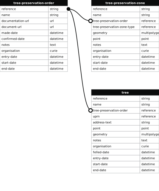
- 1000 entries with tree-preservation-order field must match the reference field in the tree preservation order dataset
THE BIRMINGHAM (LAND AT JUNCTION OF OSCOTT SCHOOL LANE & OLD OSCOTT HILL, KINGSTANDING) TPO 1980
- reference
- 328
- name
- THE BIRMINGHAM (LAND AT JUNCTION OF OSCOTT SCHOOL LANE & OLD OSCOTT HILL, KINGSTANDING) TPO 1980
- tree-preservation-order
- TPO 328
- tree-preservation-zone-type
- area
- geometry
- MULTIPOLYGON (((-1.893929 52.547279,-1.893814 52.547240,-1.893727 52.547216,-1.893554 52.547203,-1.893083 52.547172,-1.893051 52.547172,-1.893034 52.547174,-1.893022 52.547179,-1.892444 52.547551,-1.892379 52.547588,-1.892517 52.547787,-1.892624 52.547985,-1.892587 52.548009,-1.892618 52.548058,-1.892593 52.548096,-1.892711 52.548165,-1.892909 52.548296,-1.893154 52.548124,-1.893248 52.548062,-1.893358 52.547974,-1.893496 52.547853,-1.893529 52.547822,-1.893558 52.547792,-1.893666 52.547662,-1.893708 52.547605,-1.893727 52.547579,-1.893796 52.547476,-1.893878 52.547360,-1.893929 52.547279)))
- point
- POINT (-1.893112 52.547648)
- notes
- The shaded area represents those properties which fall within the outline of a Tree Preservation Order. To precisely identify trees protected by the Order, you can request a copy of the tree preservation order at the following link.
- entry-date
- 2026-10-15
- start-date
- end-date
How to fix this issue
Your data is missing a tree-preservation-order.
The tree preservation zone guidance explains how to fix the issue:
tree-preservation-order
The reference for the tree preservation order that covers this zone.
How to improve Birmingham City Council’s data
- Fix the errors indicated
- Use the check service to make sure the data meets the standard
- Publish the updated data on the endpoint URL